About Mapping L.A.
Mapping L.A. is the Los Angeles Times’ growing resource about the neighborhoods that make up Los Angeles County. It provides maps and information about demographics, crime and schools in 272 neighborhoods across the county.
- How are neighborhoods determined?
- Why does The Times portray L.A. neighborhoods differently than other sources?
- Why draw lines at all?
- Why are some cities referred to as neighborhoods?
- What technology did The Times use to make this website?
- How can I get a copy of the data?
- Where do the crime reports come from?
- Why doesn't every neighborhood have crime reports?
- When will you have crime data for my city?
- What crimes are included?
- When is the crime data updated?
- How is a crime alert triggered?
- How precise are the crime maps?
- How are per-capita crime statistics calculated?
- Can a crime be counted more than once?
- Why are some crime reports deleted?
- What are the long-term crime trends in Los Angeles?
- Income charts incorrectly stated data were inflation adjusted. They were not. (Aug. 6, 2010)
How are neighborhoods determined?
The neighborhoods are drawn and maintained by the Data Desk, a team of Times reporters and Web developers in downtown L.A. The boundaries have expanded and shifted over time and now cover all of Los Angeles County broken down into 272 neighborhoods.

The Times released the first draft of 87 neighborhoods in February 2009. That group was limited to neighborhoods within the city of Los Angeles and crafted by merging together neighboring census tracts.
Census tracts are drawn by the U.S. Census Bureau and used for tabulating demographic information, including income and ethnicity. The shapes of the tracts are frequently out of sync with the geographical, historic and socioeconomic associations that define communities. However, by using the tracts as building blocks, The Times was able to compile a statistical profile of communities, something other neighborhood boundaries do not offer.
Besides merging tracts, we’ve adjusted the lines in many cases by moving individual city blocks from one census tract to another. In each instance, we’ve adjusted the census data in proportion to the relocated block's population.
When we posted the first draft of the map, we invited users to send us comments and draft revisions. We received more than 650 user-generated maps, ranging from the precise to the bizarre.
After nearly 100 revisions, a map of 114 city neighborhoods was released in June 2009.
In June 2010, the map was expanded beyond the city to cover all of Los Angeles County. The neighborhood total more than doubled to 272 as cities as varied as Santa Monica and Industry and unincorporated areas such as Valinda and Lake Hughes landed on the map.
To define neighborhoods across the county, The Times primarily used the U.S. Census Bureau’s boundaries of 88 cities and 43 census-designated places set aside for special tabulation. The Census Bureau maps were adjusted in some areas to conform to more recent maps produced by the Los Angeles County Department of Regional Planning. In addition, The Times adopted 12 unincorporated areas proposed by the county for future designation as census places. In rare instances, the census place names were changed to reflect the names used by residents.
The remaining unincorporated areas that have not been designated by the Census Bureau or the county were generally named with a compass reference to their closest city, such as Unincorporated Carson-West.
Large rural areas were divided, as much as possible, using rivers, ridgelines or highways and given generic names.
There are 42 small unincorporated areas that either closely adjoin or are entirely within a city. For statistical purposes, The Times combined those areas with the cities. Thus the profiles of those cities will not be exactly match census publications.
Why does The Times portray L.A. neighborhoods differently than other sources?
The city of Los Angeles has posted hundreds of blue street signs denoting scores of neighborhoods — from Little Ethiopia to Little Tokyo to Little Armenia. But the city has never drawn the official boundaries of those districts.
The Thomas Guide shows the names of many communities but does not try to make clear where neighborhood boundaries are.
Neighborhood councils within the city sometimes reflect narrow political considerations, and many have a propensity for names like People Involved in Community Organizing, which don't do much to define a community. Many areas of the city have no neighborhood council, even as prized turf such as Occidental College is claimed by more than one council. The same problems apply with even greater force to homeowner associations.
ZIP Codes provide many people with a community identity but are designed only to speed up the mail. That's a nice fit in some places but unworkable in others, such as the part of Los Angeles that falls in Beverly Hills 90210. Van Nuys and North Hollywood each have four ZIP Codes. And dozens of ZIP Codes within the city are identified only as Los Angeles.
Unlike most other attempts at mapping L.A., this one follows a set of principles intended to make it visually and statistically coherent: It gathers every block of the city into reasonably compact areas leaving no enclaves, gaps, overlaps or ambiguities. Except when there was a compelling reason not to, we kept schools and other landmarks in the communities bearing their names.
We'll be the first to acknowledge that our map isn't perfect. No lines can capture the geographic diversity and demographic energy of Los Angeles.
Why draw lines at all?
Consistency is one reason. If we report that an event occurred in Van Nuys or Westwood, we want people to know exactly where we mean.
Analysis is another. Defining a strict set of boundaries allows The Times to package a wealth of data for our readers — about demographics, income, crime, schools and more — in common geographic units. Neighborhoods are easier to digest than arcane statistical areas like census tracts, and when many data sources are combined at the neighborhood level, they can yield new and interesting insights.
Why are some cities referred to as neighborhoods?
In order to standardize how we refer to areas included in Mapping L.A., The Times uses the term neighborhood to encompass everything from unincorporated areas to standalone cities to neighborhoods within cities.
For now, only the city of Los Angeles is broken up into smaller neighborhoods. However, there are plans to divide a number of the larger cities, including Long Beach, Santa Monica and Pasadena, in order to better reflect how people live their daily lives.
What technology did The Times use to make this website?
This site is built entirely with free and open-source software, including Django, Leaflet, jQuery, OpenLayers, Timemap and PostgreSQL. Thank you to all of the community members who have contributed to their development. Thanks must go especially to the GeoDjango project, which provides an astounding tool for publishing data with a geospatial database.
One note on accuracy. In order to publish maps in your Internet browser, we’ve often had to simplify the complex electronic shapes and sacrificing a bit of precision to improve the user experience.
Essentially, each neighborhood boundary consists of many points with lines connecting them to one another. Lots of points are needed to conform to curved or crooked boundaries. We used the Douglas-Peucker algorithm to reduce the number of points for faster performance. This will sacrifice some precision, but is necessary to accommodate users with older computers and browsers.
How can I get a copy of the data?
The Times neighborhood boundaries are available for use under a Creative Commons Attribution-Share Alike license. That means you can share and remix them for work as long as you credit The Los Angeles Times and release your creations under the same terms.
The boundaries can be downloaded below. Unfortunately, we cannot provide custom data. However, it can sometimes be possible to provide custom forms of information by contacting Erica Varela in Rights and Permissions. Note that minimum fees are generally $500.
- All L.A. County neighborhoods KML
- All L.A. County neighborhoods SHP
- All L.A. County neighborhoods JSON
- All L.A. County neighborhoods JSON (Simplified)
- L.A. city neighborhoods KML
- L.A. city neighborhoods SHP
- L.A. city neighborhoods JSON
- L.A. city neighborhoods JSON (Simplified)
- All L.A. County regions KML
- All L.A. County regions SHP
- All L.A. County regions JSON
Where do the crime reports come from?
The maps, statistics and lists that make up Crime L.A. were created by The Times using raw data provided through electronic records from the Los Angeles Police Department and Los Angeles County Sheriff's Department. Because The Times creates these statistics using our own neighborhood boundaries, figures seen here are different from those reported on the websites of the the LAPD and L.A. County sheriff, which typically break out crime data based on division or station areas that may not conform to the neighborhoods used by The Times.
In the course of building this site, The Times discovered significant omissions and errors in the public data file provided by the LAPD. After The Times published those findings, the LAPD’s data contractor, Lightray, eliminated many of the flaws. The data feed now provided comes directly from the department. Crimes mapped on The Times’ site begin Jan. 1, 2009, the earliest we have data.
The Times has taken additional steps to accurately place as many reported crimes as possible on our maps. While using the crime report, keep in mind that, despite advanced technologies employed by the LAPD to produce the data, there is human error found in all aspects of crime reporting.
Why doesn't every neighborhood have crime reports?
Currently, Crime L.A. includes crimes reported to the LAPD and the Sheriff’s Department, which patrols unincorporated areas of the county and has contracts to police Agoura Hills, Artesia, Avalon, Bellflower, Bradbury, Calabasas, Carson, Cerritos, Commerce, Compton, Cudahy, Diamond Bar, Duarte, Hawaiian Gardens, Hidden Hills, Industry, La Canada Flintridge, La Habra Heights, La Mirada, La Puente, Lakewood, Lancaster, Lawndale, Lomita, Lynwood, Malibu, Maywood, Norwalk, Palmdale, Paramount, Pico Rivera, Rancho Palos Verdes, Rolling Hills, Rolling Hills Estates, Rosemead, San Dimas, Santa Clarita, South El Monte, Temple City, Walnut, West Hollywood, Westlake Village, nine community college campuses, and Metropolitan Transportation Authority stations and facilities that reach into neighboring counties.
In some cases, often because a city may have unincorporated areas within or near its border, readers may see a limited number of crime reports linked to that area. Because the data is incomplete, The Times is not reporting statistics or analysis for such areas. In addition, some communities already included may have additional crime in areas policed by other agencies — such as UCLA and USC — that are not yet included in our data.
When will you have crime data for my city?
For more than a year, The Times has been contacting other jurisdictions to request electronic records relating to crime and we plan to expand Crime L.A. as more data becomes available in a useable format.
What crimes are included?
The eight most serious crimes reported to the FBI by all police agencies in the U.S. are known as Part 1 crimes. They include of four violent offenses, homicide, robbery, rape and aggravated assault — and four property crimes — burglary, theft, arson and grand theft auto. The Times has adopoted the classification system the LAPD employs, a slight variation from the federal standard. It omits arson, which the LAPD does not record, and breaks theft from vehicle out into its own category.
Here are definitions of those crimes based on the FBI’s Uniform Crime Reports and the LAPD..
- Aggravated assault: Aggravated assault is defined as the unlawful attack on a person by another for the purpose of inflicting severe or aggravated bodily injury. This type of assault involves the use of a weapon or is by other means capable of producing death or great bodily harm.
- Burglary: Burglary is defined as the unlawful entry of a structure to commit a felony or theft.
- Grand theft auto: Grand theft auto is defined as the theft or attempted theft of a motor vehicle.
- Homicide: Homicides include both murders and non-negligent manslaughters, which are defined as the willful killing of one human being by another. Killings determined to be justified are not included.
- Rape: Rape is defined as the carnal knowledge of another, forcibly and against the person's will. Assaults and attempts to commit rape by force or threat of force are also included. Statutory rape (without force) and other sex offenses are not counted as rape.
- Robbery: Robbery is defined as taking or attempting to take anything of value from the care, custody or control of a person or persons by force or threat of force or violence and/or by putting the victim in fear.
- Theft: Theft is defined as the unlawful taking, carrying, leading or riding away of property from the possession or constructive possession of another.
- Theft from vehicle: A theft from vehicle is defined as the unlawful taking of articles from a motor vehicle, whether locked or unlocked.
When is the crime data updated?
Both the Sheriff's Department and the LAPD provide new data each morning. The website updates automatically after the records are downloaded, and calculates new statistics.
However, The Times’ has found that the initial daily reports from the sheriff lag behind actual crime incidents, in some cases by as much as several weeks. The delay has made it impossible to provide short-term analysis and alerts for areas patrolled by that department. Sheriff’s officials told The Times that the delays in processing addresses are due to clerical staffing issues. For its own purposes, sheriff’s officials said the department uses reporting districts to generate internal alerts for crime spikes. However those areas are too imprecise to work in the Crime L.A. system.
Weekly summaries are based on the most recent seven-day period with complete data.
How is a crime alert triggered?
The Times’ crime alerts detect unusual jumps in crime reports in neighborhoods. Each time Crime L.A. gets new reports — usually three to five times a week — they are compared to what has been typical for that neighborhood over the past quarter. An alert is generated if violent and/or property crime reports from the most recent week are up significantly over the average. In order to qualify for an alert, the jump in crime reports must significantly surpass the average week. In addition, a minimum of three crimes must be reported.
The relative nature of the statistic means that neighborhoods historically low in crime can trigger an alert with a smaller number of crimes than is routine in high-crime neighborhoods. For instance, five violent crimes in one week would typically register an alert in Pacific Palisades, but would not in Downtown.
Currently, The Times only creates alerts in areas policed by the LAPD, which is providing up-to-date reports. Crime reports provided by the L.A. County Sheriff lag behind events, in some cases for a few weeks, making it impossible to do short-term analysis or generate alerts.
How precise are the crime maps?
Following law enforcement convention, the LAPD and Sheriff's Department obscure the actual location of each crime report, revealing only the block number or the nearest intersection. For example, 580 Main St. is identified by the police as 5XX Main St. Thus, each point on the map represents the approximate position of a crime, not the precise address. The Times places each crime on the map in roughly the center of the block in which it occurred. Crimes reported at shopping centers, parks or other large venues may appear at a formal address for the property that may be some distance away from where the crime occurred.
Not all crime reports can be mapped. Among the reasons why is that a given address might be outside the city or reported with incomplete or inaccurate information.
In the interest of providing readers as complete a report as possible, The Times mapped thousands of points by hand that, for various reasons, could not be placed automatically on a map. As a result, about two percent of crimes in LAPD areas and about five percent crimes in sheriff’s areas are not included because they could not be located.
How are per-capita crime statistics calculated?
In the city of Los Angeles, the population used to determine per capita crime in each neighborhood is based largely on the Los Angeles City Planning Department’s 2008 census tract estimates. In numerous cases, neighborhood boundaries cross census tracts, and The Times adjusted the neighborhood population by factoring the population of individual blocks as reported in the 2000 census.
Population figures outside the city of L.A. come from the 2000 Census.
Populations in Century City and Downtown were adjusted using Southern California Assn. of Governments estimates for daytime population. Although the overall population figure is based on the 2008 estimates, other demographic statistics in the neighborhood profiles are still based on the 2000 population figures. Beginning with the release of census tract data in the annual American Community Survey of 2010, the profiles will be updated annually.
Can a crime be counted more than once?
Crimes reported on or near streets that divide two neighborhoods are included in the per capita calculations for both neighborhoods. This is done to eliminate the possibility of crimes falling through tiny gaps between neighborhoods. Also, because the final digit of each address is not provided by the police agencies, The Times cannot determine on which side of the street a reported crime occurred, and therefore cannot correctly choose one over the other as the crime's home.
Why are some crime reports deleted?
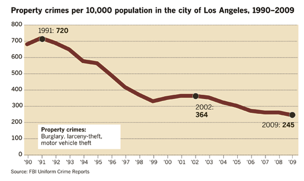
What are the long-term crime trends in Los Angeles?
Crime in the city of Los Angeles has fallen dramatically since 1990. After a slight increase earlier this decade, the decline has been steady for the last six years. The trend is continuing.
- All crimes Violent crimes Property crimes Homicides